
LiDAR for topographic mapping: Advantages and disadvantages
09/08/2023
Are you in the process of setting up topographic mapping for your site? Have you heard a lot about the benefits of LiDAR? Are you pondering if you should use LiDAR or photogrammetry? In this blog post we explore the main features of photogrammetry and LiDAR and discuss the benefits they both bring to solar PV. Particularly when considering drone-based LiDAR for topographic mapping, it is important to understand its benefits and limitations, and when to use it.
Current status quo on topographic mapping for development
To go back to the basics, traditional ground surveying (we often call it the “man-with-stick”-approach; we have all seen those) is a routine task for solar plant design and construction projects. Or rather, it should be a routine task. Too often we still see low-quality data, such as satellite data, being used as the base line for the planning and development of solar sites. While this might seem a good bargain in the beginning, it will cost manifold in the future of that assets life due to lack of precise data. This can lead to many problems, construction delays and miscalculated yields only being two of them. It goes back to what we call “technical debt”, the idea to make a quick fix that will have to be paid for later at a higher magnitude.
However, even a traditional ground surveying approach is not state of the art anymore. Nowadays, technology provides very precise, often cheaper and much more detailed options. These are photogrammetry and LiDAR.
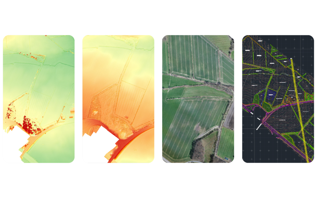
Examples of what can be created using aerial topographic data. Left to right: Digital Surface Model, Digital Terrain Model, Orthomosaic and Linework/2D CAD.
Introducing photogrammetry and LiDAR for topographic mapping
Traditional, manual on-site surveys of large areas of, e.g., 100 hectares can take weeks to be completed. As solar plants continue to grow in scale, this method becomes hugely time-consuming and costly. This is where aerial topographic mapping saves time and money compared to traditional surveys. Generating high-resolution aerial data provides a visual and spatial record of the terrain prior to construction.
For aerial topographic mapping the most common technology is photogrammetry. Photogrammetry is the process of combining thousands of images to create a three-dimensional point cloud. This is particularly useful for identifying the exact positions of surface points. The resulting data shows terrain details and elevation, and key features such as trees or buildings. Photogrammetry helps to generate full-colour two- or three-dimensional models of the terrain that are easy to visualise, interpret and process. Using this data, solar design teams can make accurate measurements, design optimal arrays and carry out shading analysis.
LiDAR for topographic mapping is the other main technology available. LiDAR is an acronym for “Light Detection and Ranging”. This remote sensing method uses millions of geo-located laser returns to measure variable distances (ranges) to the earth. The laser’s light pulses generate a precise, three-dimensional map of the terrain and its surface characteristics.
What you need to know about using LiDAR
Before deploying LiDAR for topographic mapping, there are a few things to consider. Because LiDAR sensors are rather heavy, they have in the past generally been carried by planes. They have since become lighter, but are still heavier than a standard RGB camera (1.5-4kg without batteries). While they can be carried by drones, their weight still limits the drones’ battery life, requiring frequent battery changes. As a consequence, more time is spent on-site, which leads to increased project costs, particularly when covering larger areas.
Drone-based LiDAR sensors are expensive in comparison to photogrammetry equipment. The ground control points (GCPs) needed for LiDAR data collection are heavier and more expensive than those needed for photogrammetry. As you might know, GCPs are set points on the ground with a known, pre-defined geographic location, providing exact points of reference. In addition, the varying quality of LiDAR equipment affects the quality of the data collected and processed. That’s why choosing the right LiDAR equipment for a topographical study is key. When it comes to capturing data on vegetation and wooded areas, having high quality data can make a huge difference.
Nearly all LiDAR systems now have a dual sensor with a visual camera. Consequently, they can collect and co-register LiDAR data and photogrammetry imagery at the same time. While this makes it easier to create and interpret coloured three-dimensional models, it is also more time consuming and costly. That’s because two data sets (LiDAR and photogrammetry) need to be processed, classified and compared.
When to use Photogrammetry or LiDAR for topographic mapping
The choice of technology for your topographical study mainly depends on the vegetation either on-site or adjacent to the site. In some scenarios, LiDAR offers significant advantages over photogrammetry. At sites with areas where forests or trees will be removed, LiDAR will capture the true ground elevation. The same applies to areas where low-density non-arboreal vegetation will be removed, or areas with gullies and streams covered by low-density vegetation.
However, LiDAR does not offer advantage in situations where images of near shading objects (trees, bushes) have to be captured. Additionally, on sites with individual trees with clear space between them, it would be better to use photogammetry. The reason is that photogrammetry better captures the true ground elevation around at the base of those trees. Also, in areas with dense non-arboreal vegetation or arable crop growing in fields, both LiDAR and photogrammetry have the same disadvantage: If they can’t penetrate to the ground, they cannot capture information about it.
Photogrammetry provides high quality data at a reasonable price. That’s why we think it is the best solution for projects that require visual and engineering data over larger scales. Drone-based LiDAR is suitable in cases where it is important to get good ground elevation data below certain vegetation types. It is also perfect for surveying narrow structures, such as power lines or telecom towers. Therefore, LiDAR for topographic mapping should be considered as a complementary methodology to photogrammetry, not a replacement. Given the additional costs of capturing and processing LiDAR data, we recommend to deploy it only when absolutely necessary.