You asked, we answered: FAQs from PVcase and Above Webinar
We were pleased to meet and hear you in our joint seminar with Above, the solar PV drone inspection and software solutions company. During the webinar, we were doing a dive deep into the topic: How to advance utility-scale solar design in PVcase using aerial topographic mapping. It was encouraging to see your enthusiasm and answer many on-point questions. Below we provide answers to the most popular questions in our post-seminar FAQ.
Question: Can you briefly highlight the accuracy and granularity comparison?
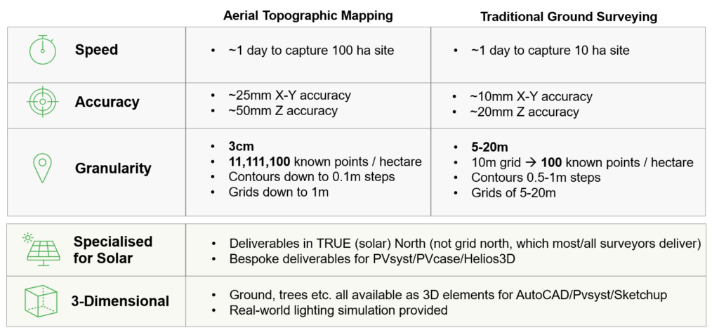
Methodology Comparison
Adrien Van den Abeele (Above): The accuracy of measurement is based on the accuracy of a single point. It doesn’t explain how many points you get over a specific area. If ground surveyors say that they have the most accurate measurements down to one nanometer, but they have a single point on a hundred-hectare site, that wouldn’t be very useful. That would be great accuracy but extremely poor granularity.
Ground surveyors usually measure accuracy by measuring points in the grid, usually situated from 5 to 20 meters from each other. So ground surveying has good accuracy because you have a person having to walk in a field taking measurements, but the time they spend on-site massively influences the cost. And the granularity suffers from it.
Granularity gives you how many points the site has. It uses the methodology of photogrammetry, which employs drones to measure points in the field every three centimeters. The beauty of drone data is that the drone captures the entire 3D model of your site. So you have elevation points for every three centimeters, and therefore granularity is immense and gives you far greater overall accuracy of your site.
Question: We have been developing more projects on abandoned lands, and sometimes we have a lot of vegetation. What is its impact on accuracy? Do we need to perform civil works (like clearing sites) before doing an aerial topographic mapping? Does Above also use LIDAR drones for point clouds?
Adrien Van den Abeele (Above): The beauty of photogrammetry is that it
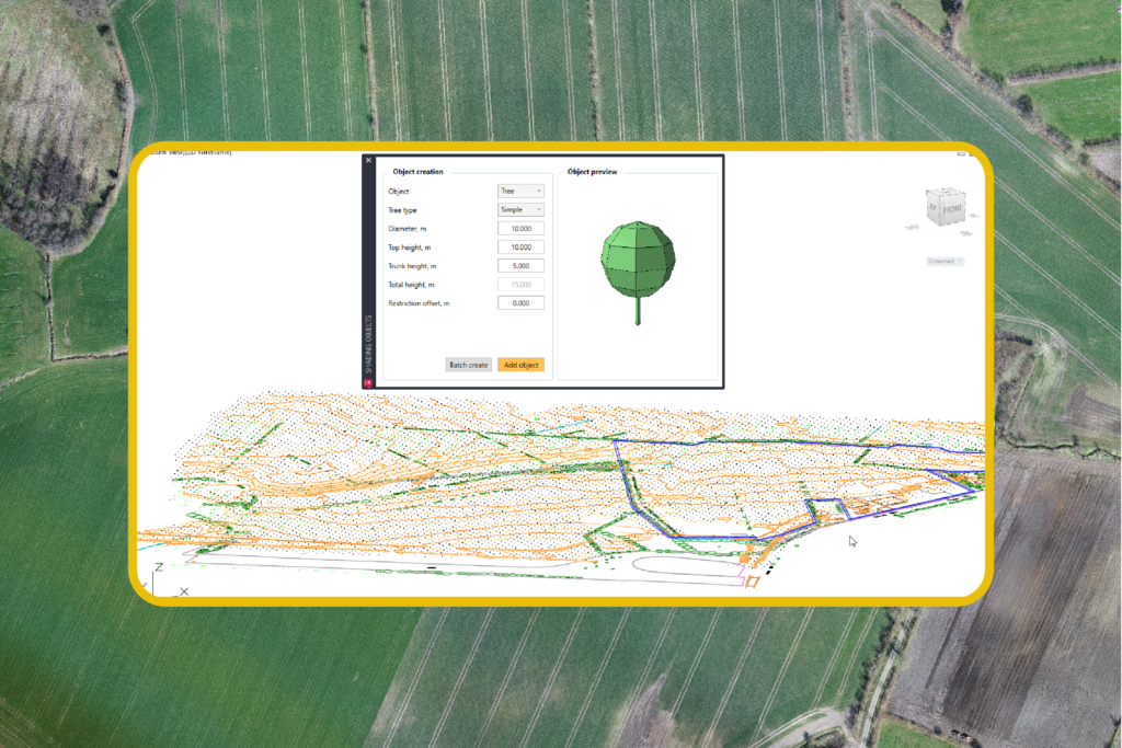
Shading Object Creation Using the Survey Data
can capture a lot of data on the ground. If you have sparse vegetation, it gives you sufficient data about your site. We can also offer a combination of aerial mapping to cover the large extent of the area, localized ground surveying, or LIDAR data for areas with very dense vegetation. However, photogrammetry alone can give you a lot of data. The photogrammetry will detect the real ground based on the flight and the different angles. The principle of photogrammetry is that it captures many views of the same area from different angles. And with those points, you can determine what is the real ground by using elevation points. Then they separate between ground and different levels of vegetation, e.g., low vegetation, trees, and the rest.
When we use photogrammetry for sparse vegetation in abandoned lands, the drone will manage to get raw data from the ground. Then we process the data from the digital service model so that the digital terrain model would have all the ground elevation. We usually use LIDAR for specific projects, but we rely on photogrammetry 95% of the time. Regarding solar, LIDAR is still too expensive and doesn’t go through deep foliage, forested areas, or crops. Hence, photogrammetry is a perfect solution for solar development.
Question: How does the new functionality “Import terrain” work?
Joseph Ziliukas (PVcase): It’s pretty simple. We are taking data from Google Earth and importing height points with a resolution of 20 meters between those height points. When we launched that functionality, we gave a request to Google Earth, and then we imported heights, points, and topography which gave the accuracy and density between those points of 20 meters. However, one should consider that even Google sometimes can’t provide precise height accuracy. Its levels of accuracy differed over the years.
Can we calculate the cut-and-fill quantity with PVcase?
Joseph Ziliukas (PVcase): Yes, definitely. It can be done in PVcase with accurate topographical data. One of the important metrics is the piling length you need to enter before calculating cut-and-fill. It’s important because the software will calculate all these values by creating the correct survey to make the correct pole lengths.

PVcase software will make your solar engineering tasks smoother and easier. If you are interested to try multiple features of PVcase Ground Mount tool, just schedule a demo here.
![]()
Above’s Digital Topographic Mapping solution enables your team to design the optimal solar plant and Achieve the most accurate Predicted Performance Ratio and Near Shading Loss calculations. Schedule a demo of Above’s Digital Topographic Mapping Solution here
